
Thermal Imaging Drones: Use Cases in Search & Rescue
Share
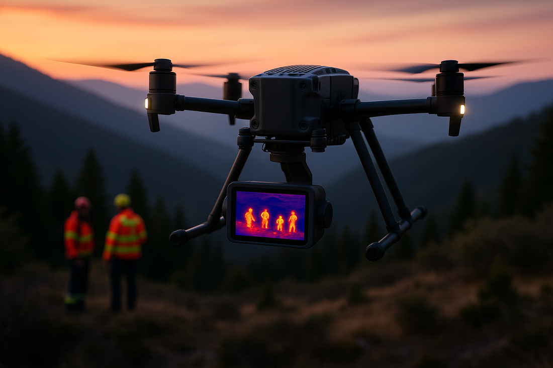
🔥Heat Signatures That Save Lives
Why Thermal Imaging Is a Game-Changer
When seconds can mean the difference between life and death, thermal imaging drones give rescue teams an extraordinary advantage. Unlike traditional cameras, thermal sensors detect infrared radiation—essentially, body heat. This allows search and rescue (SAR) teams to locate victims even in complete darkness, heavy smoke, dense forest, or snow-covered terrain where the human eye or conventional drones fall short.
Whether it's tracking a lost hiker in the mountains or spotting survivors buried under rubble, thermal drones reduce search times and boost accuracy. In high-stress rescue operations, speed isn’t just critical—it’s life-saving.
From Military to Humanitarian: Evolution of Thermal Drone Tech
Thermal imaging was once the exclusive domain of the military—used in night missions and battlefield surveillance. But today, that same advanced technology is being deployed in humanitarian efforts across the globe. With the miniaturization of thermal sensors and the rise of affordable commercial drones, this life-saving tech has become more accessible than ever before.
Public safety agencies, fire departments, disaster response teams, and volunteer SAR units are increasingly using thermal drones to extend their reach, cover more ground, and make quicker decisions. What was once cutting-edge military equipment is now an essential tool in modern search and rescue missions.
What Are Thermal Imaging Drones?
How Thermal Cameras Work: Infrared Sensing Explained
Thermal cameras don’t capture visible light like regular cameras. Instead, they detect infrared radiation—the heat emitted by all objects. Every living being, mechanical device, or structure emits heat, even at night. Thermal drone sensors translate these heat patterns into images where warmer areas appear brighter, helping operators visually identify heat sources like humans or animals.
In search and rescue missions, this means rescuers can “see” heat signatures from people even in total darkness, thick fog, or through light vegetation. It’s not about seeing clearer—it’s about seeing differently.
Key Components: Sensors, Gimbals, and FLIR Tech
A thermal imaging drone is more than just a flying camera—it’s a flying sensor system. Here are the main components that make it effective:
· Thermal Sensor (Infrared Camera): Captures the heat signatures and converts them into digital thermal images. FLIR (Forward Looking InfraRed) is the leading brand in this technology.
· Gimbal Stabilization: Keeps the thermal camera steady in flight, ensuring high-quality, non-blurry imagery during maneuvers or in windy conditions.
· Dual Payload Capability: Many drones carry both RGB (regular) and thermal cameras, allowing SAR teams to switch views in real time for better decision-making.
· GPS & Telemetry: Enables geotagging of thermal data and seamless integration with command centers for mapping and navigation.
Differences Between RGB, Night Vision, and Thermal Imaging
|
Feature |
RGB (Visible Light) |
Night Vision |
Thermal Imaging |
|
Lighting Needed |
Yes |
Yes (low light) |
No (uses heat) |
|
Vision in Complete Darkness |
No |
Limited |
Yes |
|
Sees Through Smoke/Fog |
No |
Poor |
Excellent |
|
Use Case |
Daylight visuals |
Low-light enhancement |
Body heat detection |
Unlike RGB cameras that need light and night vision systems that amplify existing light, thermal imaging works entirely on temperature differences. This makes it ideal for locating warm bodies in cold or obscured environments, a common scenario in disaster zones and wilderness rescues.
Why Thermal Drones Are Ideal for Search & Rescue (SAR)
Seeing Through Smoke, Fog, and Darkness
Search and rescue operations often occur in the worst conditions—nighttime, fog, snowfall, or smoke-filled disaster zones. Traditional drones and ground teams are limited by visibility, but thermal drones aren’t. Because they detect heat instead of light, thermal drones can see through obscurants like:
- Dense fog or low cloud cover
- Thick smoke from wildfires or explosions
- Nighttime darkness without artificial lighting
This capability gives SAR teams a powerful edge—no need to wait for better weather or daylight. Time saved means lives saved.
Locating Heat Signatures in Rugged Terrain
Mountains, forests, collapsed buildings, or flood zones are difficult to search manually. Aerial thermal imaging helps identify human-sized heat signatures from above, even if a person is:
- Lying under a tree canopy
- Partially covered by debris or rubble
- Lost in a vast, featureless landscape (like snowfields or deserts)
The drone’s birds-eye view combined with thermal sensitivity drastically improves detection rates, helping responders cover more ground in less time.
Faster Response = Higher Survival Rates
In most SAR cases, especially involving injured, cold-exposed, or trapped individuals, the first few hours are critical. The faster a person is found, the higher their chances of survival.
Thermal drones help by:
- Reducing search time from hours to minutes
- Pinpointing exact locations for ground teams to reach faster
- Avoiding false positives by focusing on active heat sources
Studies have shown that using drones with thermal imaging can increase the effectiveness of SAR missions by up to 70% compared to traditional ground searches.
Forest & Mountain Rescue Missions
Finding Lost Hikers with Aerial Thermal Scans
Dense forests and mountainous terrain are among the hardest environments for search teams. Trees, elevation changes, and limited visibility slow down manual efforts. But thermal imaging drones cut through those limitations by detecting body heat from above—even if the person is:
- Lying under leaves or tree cover
- Injured and immobile on a cliff or slope
- Wearing camouflaged or dark clothing that blends with surroundings
Drones can scan vast areas in a fraction of the time it would take humans on foot, dramatically increasing the chance of locating someone before exposure becomes fatal.
Real-Time Coordination with Ground Teams
Once a drone detects a potential heat signature, it sends live coordinates and video feeds to rescuers on the ground. This means:
- Faster team deployment to precise locations
- Better allocation of resources based on heat clusters
- Safer and more strategic movement through difficult terrain
In some cases, drones are equipped with voice speakers or drop kits to provide instructions, flares, or basic aid to victims until rescue teams arrive.
Case Study: Successful Rescue in the Himalayas
In 2023, a rescue team in the Indian Himalayas used a thermal drone to find two missing trekkers trapped on a snowy ridge during a blizzard. Helicopters couldn’t fly due to poor visibility, but the drone picked up faint heat signatures under a light snow covering. The GPS-guided data led rescuers to the exact spot, saving both hikers from hypothermia.
This case—and many others—highlights the game-changing role thermal drones play in high-altitude and wilderness rescues, where time and terrain are critical obstacles.
Disaster Response: Floods, Earthquakes & Landslides
Detecting Trapped Survivors Under Rubble
In the aftermath of earthquakes or building collapses, every second matters—but unstable debris and unsafe structures delay human rescuers. Thermal drones can scan the rubble from above and detect body heat rising from voids or cracks, even when victims are invisible to the naked eye.
This allows first responders to:
- Prioritize search zones based on thermal activity
- Avoid unnecessary digging in cold, lifeless areas
- Pinpoint survivors faster, improving rescue success rates
Drones can operate over collapsed bridges, cracked roads, or destroyed infrastructure where ground access is nearly impossible.
Locating Stranded Victims in Floodwaters
Floods present a different challenge: fast-moving water, displaced people, and wide search areas. Traditional SAR boats may miss people clinging to rooftops, trees, or floating debris—especially at night.
Thermal drones help by:
- Detecting body heat on rooftops or high ground
- Scanning large flood zones quickly and efficiently
- Guiding boats or helicopters directly to survivors
Even in murky or partially submerged situations, a person's head or upper body may emit enough heat for detection—especially in early hours.
Mapping Danger Zones for Emergency Crews
Thermal drones don’t just locate people—they also help responders assess risk in real-time. For example:
- Identifying hot spots from ruptured gas lines or fires
- Monitoring landslide-prone slopes for movement
- Scanning floodwaters for submerged hazards
Urban Search After Structural Collapses
Spotting Heat Through Concrete and Debris
Urban disasters like explosions, bombings, fires, and building collapses often leave people buried beneath layers of rubble. Human rescuers using dogs or sound sensors may miss victims—especially those unconscious or unable to cry for help.
Thermal drones offer a unique advantage: they can detect faint heat signatures rising through cracks in debris, asphalt, or concrete.
Even if just a hand or portion of the body is exposed, a high-sensitivity thermal sensor can identify the anomaly and alert teams to hidden survivors.
Coordinating with Fire Departments in Real-Time
During urban disasters, multiple emergency agencies are often involved—firefighters, paramedics, law enforcement, civil defense. Thermal drones help unify their efforts by:
- Providing live thermal video to command centers
- Marking active heat zones with GPS coordinates
- Guiding rescue workers away from hot spots (fires or flammable materials)
- Supporting safe entry points for first responders based on thermal data
Some drones also carry loudspeakers or thermal drop sensors to interact with survivors or alert emergency crews to critical findings.
Use Case: Beirut Explosion Rescue Operation
In 2020, the devastating explosion at the Beirut port flattened entire city blocks. Amid the chaos, a Chilean rescue team used a thermal drone to detect faint heat and heartbeat signals from under collapsed buildings days after the initial blast.
While the survivor was later found deceased, the case showed how thermal drones extended the search window and offered hope where conventional methods had failed.
This mission became a global example of how urban SAR operations are evolving with drone-based thermal technology.
🛟 Maritime and Coastline Rescues
Identifying Overboard Victims in Open Water
Rescuing people lost at sea is one of the most difficult SAR operations. The ocean is vast, dynamic, and often dangerous. Victims may be hypothermic, floating low in the water, or completely invisible to rescue boats and helicopters. Thermal drones can make a difference by:
- Detecting body heat against cold water backgrounds
- Scanning large stretches of ocean from an aerial view
- Spotting survivors on life rafts, buoys, or clinging to wreckage
Because water cools quickly, the thermal contrast of a warm body becomes a sharp, high-contrast signature—especially during nighttime or in cold climates.
Smart Features Powering Rescue Missions
AI-Based Target Recognition and Thermal Tagging
Modern thermal drones go beyond just showing a heat signature—they now come equipped with AI algorithms that detect, identify, and track human heat patterns automatically. These smart features allow drones to:
- Distinguish between humans, animals, and inanimate heat sources
- Flag multiple targets and prioritize based on movement or body temperature
- Reduce operator error and improve search accuracy in large-scale operations
Some models can even lock onto moving heat targets, maintaining a tracking pattern to guide responders directly to the person’s last known location.
GPS Integration and Heat Signature Mapping
Every thermal detection can be instantly geotagged with exact GPS coordinates, helping SAR teams:
- Navigate straight to the target without guesswork
- Build real-time heat maps of the search area
- Log and analyze data for post-mission debriefs or pattern detection
This is especially useful in multi-drone missions, where thermal data from different units is integrated into a central dashboard for command and control.
Real-Time Data Streaming to Rescue Command Centers
Today’s thermal drones can stream live thermal video feeds to mobile devices, rescue vans, or emergency operation centers. This feature enables:
- Faster decision-making by commanders without being on-site
- Coordination between aerial and ground units with synchronized visuals
- Immediate thermal feedback to adjust search areas or deploy resources faster
In high-stakes situations, real-time connectivity can be the difference between life and death. It turns thermal drones into mobile SAR intelligence units.
Long-Range Detection with Fixed-Wing Thermal Drones
Unlike multirotor drones, fixed-wing thermal drones can cover much larger distances over coastal and offshore areas. These are particularly useful for:
- Monitoring shipping lanes or offshore platforms
- Supporting large-scale maritime patrols during mass rescue events
- Relaying thermal video to naval or coast guard ships in real time
These drones often have extended battery life, higher altitude range, and powerful zoom capabilities—essential for search missions several kilometers out to sea.
Limitations in Rough Weather or Choppy Seas
While thermal drones are highly effective, they’re not without challenges over water. Limitations include:
- Wind and weather instability affecting drone flight
- Wave reflections sometimes causing false heat signals
- Shorter detection range if the victim is mostly submerged or unconscious
Despite these challenges, when paired with marine teams and helicopters, thermal drones dramatically improve search accuracy and increase the window of survival for overboard individuals.
Smart Features Powering Rescue Missions
AI-Based Target Recognition and Thermal Tagging
Modern thermal drones go beyond just showing a heat signature—they now come equipped with AI algorithms that detect, identify, and track human heat patterns automatically. These smart features allow drones to:
- Distinguish between humans, animals, and inanimate heat sources
- Flag multiple targets and prioritize based on movement or body temperature
- Reduce operator error and improve search accuracy in large-scale operations
Some models can even lock onto moving heat targets, maintaining a tracking pattern to guide responders directly to the person’s last known location.
GPS Integration and Heat Signature Mapping
Every thermal detection can be instantly geotagged with exact GPS coordinates, helping SAR teams:
- Navigate straight to the target without guesswork
- Build real-time heat maps of the search area
- Log and analyze data for post-mission debriefs or pattern detection
This is especially useful in multi-drone missions, where thermal data from different units is integrated into a central dashboard for command and control.
Real-Time Data Streaming to Rescue Command Centers
Today’s thermal drones can stream live thermal video feeds to mobile devices, rescue vans, or emergency operation centers. This feature enables:
- Faster decision-making by commanders without being on-site
- Coordination between aerial and ground units with synchronized visuals
- Immediate thermal feedback to adjust search areas or deploy resources faster
In high-stakes situations, real-time connectivity can be the difference between life and death. It turns thermal drones into mobile SAR intelligence units.
Challenges and Limitations of Thermal Drones
Battery Life vs. Flight Time in Cold Environments
One of the biggest operational hurdles for thermal drones in SAR missions is limited battery life, especially in cold or high-altitude environments. Low temperatures drain lithium-polymer batteries quickly, reducing:
- Flight duration—cutting missions short when every minute counts
- Sensor performance—thermal cameras may take longer to calibrate
- Coverage area—teams may need multiple drones or quick recharging setups
This makes mission planning and backup power essential during operations in winter or mountainous terrain. Conclusion: Eyes That Save Lives from Above
Thermal imaging drones have revolutionized search and rescue missions by giving teams the ability to see the unseen—heat. From tracking hikers in dense forests to locating earthquake survivors under rubble and spotting stranded victims at sea, these drones drastically reduce search times and increase survival rates.
With the addition of AI, GPS mapping, real-time data streaming, and ever-improving flight technology, thermal drones are no longer a futuristic luxury—they are essential, life-saving tools in modern SAR operations.
As challenges like natural disasters and climate emergencies rise, so too does the demand for smarter, faster, and more precise response methods—and thermal drones are leading that charge.
❓ FAQs: Thermal Imaging Drones in Search & Rescue
Q1: Can thermal drones detect people through walls or roofs?
A: No. Thermal drones can detect heat through light materials like fabric or foliage, but not through thick walls, metal, or solid roofs. They can sometimes detect heat escaping from gaps or cracks.
Q2: How far can a thermal drone “see” a human body?
A: High-end thermal drones can detect human-sized heat signatures from 100 to 400 feet depending on altitude, sensor quality, weather conditions, and temperature contrast.
Q3: Are thermal drones effective in rain, snow, or fog?
A: Yes. Thermal cameras perform well in low-visibility conditions like fog, light rain, and snow, where RGB and night vision cameras struggle. However, heavy precipitation or strong winds may still limit drone flight stability and detection accuracy.
Q4: Do you need a license to fly a thermal drone in rescue missions?
A: Yes. In most countries, flying drones for SAR or commercial use requires a certified drone pilot license, and sometimes emergency airspace clearance. Local aviation authorities regulate this.
Q5: What’s the best type of drone for SAR: multirotor or fixed-wing?
A: Multirotor drones are ideal for tight, complex urban or mountainous rescues due to their stability and maneuverability. Fixed-wing drones are better for covering wide areas, such as in floods or maritime searches, thanks to longer flight times and range.
False Positives: Animals vs. Huma
Thermal cameras detect heat—but not all heat sources are people. Wildlife (like deer or dogs), machinery, fires, or even sun-warmed rocks can create false heat signatures that distract rescue teams. While AI is improving accuracy, operators must still:
- Verify targets using dual-camera (RGB + thermal) systems
- Analyze movement patterns and relative heat intensities
- Cross-check locations with on-ground intelligence
Without trained interpretation, thermal imaging can become noisy data, especially in forested or post-disaster zones.
Legal and Ethical Considerations in Crisis Zones
Thermal drones are powerful—but with that power comes responsibility. Ethical and legal issues include:
- Privacy concerns: Drones flying over private property or scanning people without consent can spark legal backlash
- Airspace regulations: SAR teams must often get emergency flight permissions—especially in urban or no-fly zones
- Data sensitivity: Thermal footage from disaster scenes may capture disturbing or identifiable content, requiring careful handling and secure storage
Proper licensing, SOPs, and transparency are crucial to avoid legal issues and ensure community trust.